 |
 02-07-2023, 11:26 AM
|
#1
|
|
Platinum Member
Join Date: Oct 2014
Location: League City, TX
Posts: 1,168
|
 Custom mapping state of the art?
I glanced at the sticky (over a decade old now) and the rest of this child forum, but could not find an answer to this:
What is the best customize-able route mapper out there today, in 2023?
Are we still looking at Google My Maps, or are there alternatives?
Backstory:
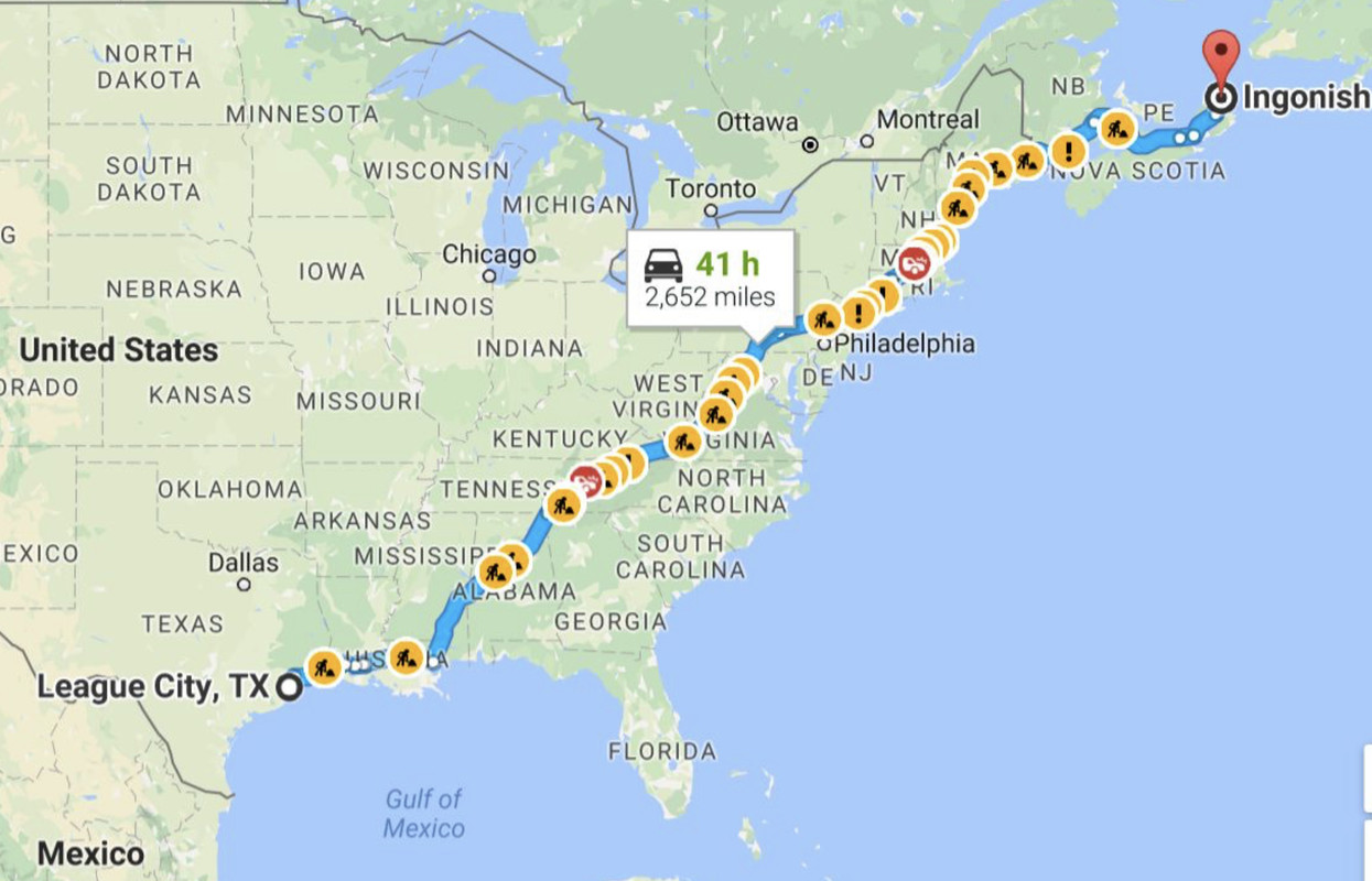
Such a tool would be a lifesaver for us because I need to shed irrelevant data and just plot the resources and contingencies that I need along our annual 3,000 mile travel route (image below).
About 5 years ago, my husband and I toyed with the idea of cracking our Garmins code and programming it to display only what we want, instead of all the useless clutter that is factory-loaded. In the screenshot below, you can see a black and white Sprinter face icon on the Garmin screengrab. Thats part of what my husband accomplished while scoping such a project - Garmins do not automatically display Sprinter-only repair shops. He probably also installed the Buc-ees icon (smiling beaver) and maybe the Cracker Barrel as well. However, the Garmin was never set up to facilitate any kind of developer role, and the amount of **TIME** that it would have taken us
it was degenerative, so we didnt proceed with that effort.
Since that time, I have waited for other options to appear, but nothing has jumped out at me. Do yall know of anything new on the market?
Thanks.

|

|

|
|
02-07-2023, 12:45 PM
|
#2
|
|
Platinum Member
Join Date: Oct 2014
Location: League City, TX
Posts: 1,168
|
Heres a little bit more info on our efforts 5 years ago.
The state of the art at that time was that points of interest (POIs) were obtainable from a number of collaborative sites such as POI Factory. But once incorporated into the Garmin, there was no way to invoke them, to preferentially display them (eliminating clutter) or to interact with them. They just sat there as passive icons, which was not what I was aiming for because I typically navigate solo, without someone else in the passengers seat doing the headwork for me. I need the GPS to be doing some of that work.
At one point, I wondered if I might be able to incorporate Allstays into a solution, and so I was in communication with its developer, but it never amounted to any clear pathway. In the image below, I was questioning if maybe I paid for the Allstays Pro version, it would supply some of the functionality that I sought.
Anyway, bottom line, the whole endeavor was a dogs breakfast. But 5 more years have passed, and there may be more elegant solutions now.


|
|
|
|
|
02-07-2023, 01:08 PM
|
#3
|
|
Platinum Member
Join Date: Aug 2010
Location: Minnesota
Posts: 11,991
|
Custom routings for the GPS have been an interest to me for quite a while.
We started out over a decade ago with Microsoft Streets and trips which really worked quite well running on an 11" laptop in the cabin. When S&T was no longer updated we got a TomTom that we could import from mapping programs into, but the way they handled it all was horrible because the GPS would freelance a different route between waypoints than the mapping program had put in.
We then switched to Garmin and started the Garmin Basecamp for custom routes. I can lay out a route on the PC or laptop and transfer it in to the Garmin GPS very quickly. Basecamp is old and clunky to use and there are few really good instructions to learn the tricks to make it use all the quite large capabilities it has in it. It has a long learning curve unless you can either get some help or are very good at computer programmer styles and patterns.
I do wish that Basecamp would get improved a bit to make it easier to learn, but in other ways I hope it doesn't because the often automate a lot of functions these days in programs and take away the ability to do things in ways that you like.
Although we don't do it, there are folks that have imported POI information from other data bases into Basecamp which then can put them into the Garmin GPS for use, IIRC. I don't how easy or accurate it is however or if truly can be done for most information.
I recently laid out a 5000 mile custom route that will cover about 4-5 weeks. It chooses the exact roads we want, which is the biggest challenge in GPS programming, IMO. On one section of about 400 miles down the Appalachian Ridge, I have about 50 shaping points to keep us on the Skyline Drive, Blue Ridge Parkway, and Smoky Mountain Parkway. The file system is broken down to 5 major zones and then there are multiple subfolders in them. The actual trips are in the subfolders. This allows me to easily put in the next day or couple of days information into the GPS from the laptop so the GPS is not cluttered with many trips or one huge trip to make sure to pick up again every day. Our POI of campgrounds, sites, hiking trails is included with trip data for that segment.
I have a couple recent threads on the forum on the latest organizing methods used to hugely speed up using Basecamp to program complicated routes. I have mostly eliminated the use of drag and drop, which seems counter intuitive, but works much better . It also allows for very easy modification of routes on the laptop while on the road as all the shaping points are easily identified on the route.
Basecamp is terribly weak at finding things by location, address, name, etc, so I have mostly given up on that. I use Google Maps for that and use the shortcut click on Google Maps to copy the GPS coordinates for whatever it was I searched. Basecamp finds coordinates very well and it's east to put them in. Many POIs also give their coordinates on websites and Apps so pretty easy also. We use Allstays Pro and finding campground exact locations and putting them into Basecamp is easy using the coordinates.
It would be interesting the hear what kinds of features and benefits you want to be able to get. To us full custom routes, easy modifications to the of routes, POI finding and easy of finding them when driving is nice but hard to do unless you put a lot of databases into the Garmin GPS and, of course, eliminating the GPS tendencies to freelance routes to something you don't want. Garmin has gotten better in handling spontaneous going of the programmed route on recent models, so if you want to take a side trip because you see a road sign or such you generally can and pick up the route again later. If there is a detour you have to take it will not matter if you don't go through a shaping point that is on the original route it doesn't matter. Most GPSs, I think, still make you delete those points or it will constantly try to take you back the them until you do.
I wonder if there will be any really big improvements in GPS mapping programs in the future as so many people just seem to be OK with taking whatever route the GPS spits out. It probably isn't economically feasible to develop a route planner that is modern and linked to many different databases and is very full featured. We don't really hear of a lot of people that do, or want to do, full routings, but for some of us it essential because of the way we travel.
|

|
|
|
02-07-2023, 01:18 PM
|
#4
|
|
Platinum Member
Join Date: Aug 2010
Location: Minnesota
Posts: 11,991
|
I just saw the second post and on Allstays Pro, are you using it on the phone or laptop? I have Android so can't use the phone unless on internet connection, but on the laptop the coordinates and search by state are quite easy to use. I generally will find multiple campgrounds along our route and put them into the GPS trip as shaping points, with a waypoint along the route just before a turn off to the campground part of the route so we get notification. If we want to go the campground we turn, if we decide to keep going further we just keep going to the next destination off route until we get back on route. The Garmin then picks it up and ignores tying to get us to go the campground we missed.
|
|
|
|
|
02-07-2023, 01:33 PM
|
#5
|
|
Platinum Member
Join Date: Oct 2018
Location: MN
Posts: 499
|
Sygic has the ability to display POI categories on the main map screen while traveling. The type of POI to display is configurable - I.E 'Rest Areas', 'Gas Stations', and 'Resturants', but not to the level of detail such as only 'Cracker Barrel' resturants. Their POI database is less comprehensive though.
The latest Garmin has the ability to create a custom POI search and display the distance to those POI's on the main map also. I can create a search for 'Cracker Barrel' and it'll display the distance to the next Cracker Barrel that is along the route. For example, I just configured my year-old Garmin to show the distance to all Gas Stations, Rest Areas, and Cracker Barrels on the main nav screen. It's limited to three custom searches though.
I think that you can still add custom POI's to a Garmin, though the mechanism is convoluted and clunky.
Edit: It's not clear to me whether or not you can add a custom POI file and have those POIs be configured to show on screen while driving. Still playing with that.
|
|
|
|
|
02-07-2023, 05:57 PM
|
#6
|
|
Platinum Member
Join Date: Oct 2014
Location: League City, TX
Posts: 1,168
|
Scooping together various responses to questions both direct and implied
Basically I would like every one of my customized POIs placed on a map that has no other clutter on it. I would like them to be activated by touch if I decide I want to navigate to one of them. And I would appreciate proactive chirps out of the GPS informing me of which of my POIs are ahead.
Several things happened in 2022 to re-surface this dream of mine:
(1) Curse the T1N Sprinter, because OF COURSE my husband started having fatal EGR valve problems north of Tennessee. It doesnt matter what we do with that rotten thing - its an unfixable problem (details omitted for brevity). I (back in Houston by that time) had to drop everything and spend 2 hours tracking down someone in the state of Tennessee who might be able to either fix or jury rig that piece of crap. Ordinarily that would not be an imposition, but we were dealing with another family emergency at the same time, which was also why my husband could not simply afford to pull over for 2 hours and research it himself from the road. I should have had all 3,000 miles of Sprinter-related resources rolled up into an accessible, activate-able personal GPS database ahead of time, but I didnt know what platform I was ultimately going to be working with, so guess what?? It never got done.
(2) We towed a small utility trailer for the first time in 2022, which significantly changed our over-the-road boondocking options. It eliminated some possible waypoints but opened us up to some really good options that I had not considered previously because my tail was not long enough to require me to expand my imagination accordingly. I should have had all THAT rolled up into a personalized database ahead of time also.
(3) Theres SO MUCH that I would like to add for contingency purposes. There is no end to what can go wrong on the highways through NJ, NY, CT, and MA in particular. If my schedule gets scuttled because of some catastrophe that shuts all attainable routes, then I would like to revector to some POI of my choice. But if Im behind a fatal wreck, I cant START that research at that point. If Im the only human onboard doing a 3,000 mile solo run, I simply dont have the mental bandwidth for that kind of thing. I need to compile it in advance.
I would really like to build something useable and I have several months worth of morning coffee times to focus on it, if only I knew what that thing would be.
What do long-haul truckers do? How do THEY navigate to the resources that they need?
|
|
|
|
|
02-07-2023, 07:00 PM
|
#7
|
|
Site Team
Join Date: Jul 2013
Posts: 5,339
|
I have long dreamed of the mapping app that you describe. There are basically two features that are needed but rarely found in commercial routing algorithms, both having to do with "route awareness".
1) POI search that is filtered by type and limited by distance from the route (as opposed to distance from a point).
2) Direction-awareness, so you can search where you are going, not where you have been.
Like you, it amazes me that these obvious features are so scarce, and as far as I know, nobody has done it well. The best I have seen was the AAA "virtual TripTik" website, which came pretty close. Haven't looked at them for several years, though, so it has probably been screwed up by now.
If you really were iterested in rolling your own, there are quite a few of open-source mapping and georeferencing projects around these days. I would start with OpenStreetMap, although they are much better at the maps themselves than POI data. Many other sources around, though. Home Assistant (surprisingly) has many of the pieces of this floating around in its vast cauldron of random features.
__________________
Now: 2022 Fully-custom buildout (Ford Transit EcoBoost AWD)
Formerly: 2005 Airstream Interstate (Sprinter 2500 T1N)
2014 Great West Vans Legend SE (Sprinter 3500 NCV3 I4)
|
|
|
|
|
02-07-2023, 07:21 PM
|
#8
|
|
Platinum Member
Join Date: Aug 2010
Location: Minnesota
Posts: 11,991
|
That is quite a list of stuff, like many of us have. Responses in blue below.
Quote:
Originally Posted by InterBlog

Scooping together various responses to questions both direct and implied
Basically I would like every one of my customized POIs placed on a map that has no other clutter on it. I would like them to be activated by touch if I decide I want to navigate to one of them. And I would appreciate proactive chirps out of the GPS informing me of which of my POIs are ahead. After your second post I looked around at Garmin in the internet about some of the stuff with POIs mentioned. You can, AFAIK, shut off various categories of POIs. It appears from what I saw that you can make a list of your POIs ahead of time in Basecamp and load them into the GPS as POI file. What I don't know and need to trial and error a bit is what you can do with that file once it is the GPS. My hope would be you put the POI into another category to turn on or have just a file of the POI to see if needed. I don't know if a created POI would be activated by a touch of the screen, but it may be possible once they created and loaded. You can do that with any point on the map be doing an add to route type procedure of touching the screen where you want to go and following the prompts. When you have any waypoint in a trip you can change the properties of it to have it announce it when you get a settable distance away better than a chirp even. I just found that today and we will probably be starting to use that once we are traveling again in the spring and summer. We currently use destinations instead of waypoints to do that, but that way has downsides. I could not find what the call waypoints, though, in a trip as in does include shaping points or not which it would have to do.
Several things happened in 2022 to re-surface this dream of mine:
(1) Curse the T1N Sprinter, because OF COURSE my husband started having fatal EGR valve problems north of Tennessee. It doesnt matter what we do with that rotten thing - its an unfixable problem (details omitted for brevity). I (back in Houston by that time) had to drop everything and spend 2 hours tracking down someone in the state of Tennessee who might be able to either fix or jury rig that piece of crap. Ordinarily that would not be an imposition, but we were dealing with another family emergency at the same time, which was also why my husband could not simply afford to pull over for 2 hours and research it himself from the road. I should have had all 3,000 miles of Sprinter-related resources rolled up into an accessible, activate-able personal GPS database ahead of time, but I didnt know what platform I was ultimately going to be working with, so guess what?? It never got done. In this case, you could have a lot of the Sprinter stuff premade in a files on a laptop so if the above scenario happened you could pull up a general area along you route if filed by location like states so easy to find. You could even do this remotely in above case you could be sent the route if it was in Basecamp, put in the POIs for the close Sprinter places and send in an email to be downloaded to the GPS from Basecamp.
(2) We towed a small utility trailer for the first time in 2022, which significantly changed our over-the-road boondocking options. It eliminated some possible waypoints but opened us up to some really good options that I had not considered previously because my tail was not long enough to require me to expand my imagination accordingly. I should have had all THAT rolled up into a personalized database ahead of time also. Absolutely, I always try to check things related to our van and what we are looking for before adding potential stops to a trip. Sucks to get there and find out it isn't what you want or you can't stay there. If you know your route, which you will I assume, you can just add waypoints to the trip in Basecamp and code them to display in order in the list of waypoints for that trip in Basecamp. That will put them into the GPS when you trip so you can find the easily. You can do that two ways, one by putting them all into the trip as shaping points so the show in the open route list in Basecamp and changing the properties to announce them. The other is just put them into the trip file as waypoints but don't add them to the route. They will then be in the GPS to access, but not show up on the actual route or announce, I think, but untested now.
(3) Theres SO MUCH that I would like to add for contingency purposes. There is no end to what can go wrong on the highways through NJ, NY, CT, and MA in particular. If my schedule gets scuttled because of some catastrophe that shuts all attainable routes, then I would like to revector to some POI of my choice. But if Im behind a fatal wreck, I cant START that research at that point. If Im the only human onboard doing a 3,000 mile solo run, I simply dont have the mental bandwidth for that kind of thing. I need to compile it in advance. We pretty much do this already on long travel days, although I don't have it van related in general because you can get Chey service everwhere easily. Just add waypoints to the trip file, but not the actual programmed route along an alternate route. If the road is blocked, just do a route through the new points on Basecamp and load it. This way you can preplan for a reroute the way you want to go instead of the GPS.
I would really like to build something useable and I have several months worth of morning coffee times to focus on it, if only I knew what that thing would be. I think you would be able to do a lot of it through Basecamp, if you are a basecamp user. Doing a long route and entering it manually into the GPS is borderline impossible to me, so Basecamp is a given for us. You would also need the Garmin POI creator program if you want to bulk load the POIs. I just found out that program exists in my looking today.
What do long-haul truckers do? How do THEY navigate to the resources that they need?
|
They use Trucker GPS units, I think, and on them the POI they get are tuned to things trucker go to all the time. Truck stops, big rig service centers, load limits, length and height limits etc. The GPS can be set to choose a route the fits the rig size and exclusions, I think.
How do you currently lay out a custom route and get it into the GPS?
|
|
|
|
|
02-07-2023, 09:17 PM
|
#9
|
|
Platinum Member
Join Date: Oct 2018
Location: MN
Posts: 499
|
Quote:
|
You would also need the Garmin POI creator program if you want to bulk load the POIs. I just found out that program exists in my looking today.
|
I've used that to load custom POI files a few times. The POIs will show up in searches so you can navigate to them, but so far I 'm not able to make them automatically show up on the map and/or alert as you approach them, though the docs indicated that should be possible.
Quote:
1) POI search that is filtered by type and limited by distance from the route (as opposed to distance from a point).
2) Direction-awareness, so you can search where you are going, not where you have been.
|
I believe Google maps does this. For a given category (I.E. Gas Stations) it shows how far off the route (in minutes), along the route in the direction you are going, not distance to POI in miles. Sygic shows distance in miles along the route or selected categories of POIs. For gas stations and rest stops, I'd rather have distance in miles to POI (Sygic), not how far off the route (Google). If I only have 50 miles of gas in my tank, I need to know if there is a gas station within 49.999 miles of where I'm at right now. 
|
|
|
|
|
02-07-2023, 09:26 PM
|
#10
|
|
Platinum Member
Join Date: Oct 2014
Location: League City, TX
Posts: 1,168
|
Quote:
Originally Posted by booster
….How do you currently lay out a custom route and get it into the GPS?
|
My response is pathetic, but good for a laugh: I don’t. I memorized it instead. All three thousand miles of it.

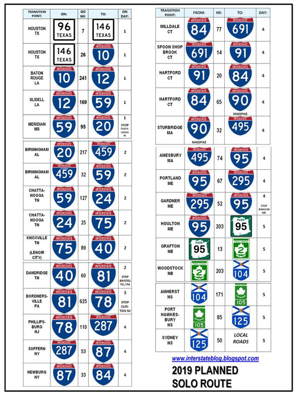
And in case I get involuntarily detoured by road work or catastrophe, or I’m too freaking tired to trust my own mind to keep it straight, I printed out a physical cheat sheet (image below) and I keep it on the seat next to me, just in case I need a reality check. No words, just highway signs, for maximum recognition, minimum use of brain cells.
It was never my intention to do this, but the GPS won’t hold my route reliably, so I just do it manually.
And God forbid I should ever want a Subway sandwich, because what was posted above is true: my Garmin will do everything in its power to send me backwards along my route, rather than identifying a freakin’ resource somewhere ahead of me. I can’t believe that’s the state of the art right now.
EDIT: I should probably clarify that I do use the Garmin - but mostly to shout “FIND PLACE” at it, which 75% of the time turns into a useless fishing expedition. But occasionally I score something that is useful to me and that should have been in my dream database, and I’m just sitting there driving anyway, so I don’t mind shouting twelve attempted commands every time I want to use it.
|
|
|
|
|
02-07-2023, 10:27 PM
|
#11
|
|
Platinum Member
Join Date: Aug 2010
Location: Minnesota
Posts: 11,991
|
Quote:
Originally Posted by InterBlog
My response is pathetic, but good for a laugh: I dont. I memorized it instead. All three thousand miles of it.
And in case I get involuntarily detoured by road work or catastrophe, or Im too freaking tired to trust my own mind to keep it straight, I printed out a physical cheat sheet (image below) and I keep it on the seat next to me, just in case I need a reality check. No words, just highway signs, for maximum recognition, minimum use of brain cells.
It was never my intention to do this, but the GPS wont hold my route reliably, so I just do it manually.
And God forbid I should ever want a Subway sandwich, because what was posted above is true: my Garmin will do everything in its power to send me backwards along my route, rather than identifying a freakin resource somewhere ahead of me. I cant believe thats the state of the art right now.
EDIT: I should probably clarify that I do use the Garmin - but mostly to shout FIND PLACE at it, which 75% of the time turns into a useless fishing expedition. But occasionally I score something that is useful to me and that should have been in my dream database, and Im just sitting there driving anyway, so I dont mind shouting twelve attempted commands every time I want to use it.
|
My memory and attention span would last closer to 3 miles than 3000 miles. 
The way you want to preplan would certainly look like you could benefit from learning Basecamp to have it all done and ready to go, without the freelancing by the GPS.
Side trips, even random ones, can usually be handled fairly easily by using the up ahead feature to find restaurants or whatever. With a preplanned route and the newer units, you can just shut off the route and then tell it what to find as it starting a new route, because you are. It should be able to find something you want, especially if you have some saved in POI files. To get back on your preplanned route you just open the route and when prompted for the first destination just push enter route at nearest point and it will take you there and pick up the route from there. It might take you slightly backward if that is the closest point, but that is kind of rare. You usually will go back the same way you got to you new little route to Subway or whatever.
I created a 5000 mile trip with multiple trips within it for ease of use and many shaping points to keep on the selected roads in barely half a day using the latest organizing/sorting fudges to get Basecamp to do the hard parts better. I can also save that trip completely to repeat any part of it later if we choose to, so good to have ready.
Even though we have two people, I have to do much like I was alone for the routings as the copilot doesn't read maps or do much on the GPS.
|
|
|
|
|
02-08-2023, 01:07 AM
|
#12
|
|
Site Team
Join Date: Jul 2013
Posts: 5,339
|
Quote:
Originally Posted by @Michael
I believe Google maps does this.
|
Google maps purports to do this. Maybe it is just user error, but when I try to do anything useful with it, things very quickly fall apart.
I tried plotting a cross-country route, and pressed the "hotels" button. I got maybe half a dozen random hotels (well, probably ones that paid the most to Google), with huge gaps showing nothing. I tried searching for "Hampton Inns along this route" and got similar results--a few in the middle of nowhere, and places like Amarillo (which has two) showing nothing. I tried using the slider to filter by price, choosing > $60 and <$160. It said "no matches". This wasn't exactly living the dream.
__________________
Now: 2022 Fully-custom buildout (Ford Transit EcoBoost AWD)
Formerly: 2005 Airstream Interstate (Sprinter 2500 T1N)
2014 Great West Vans Legend SE (Sprinter 3500 NCV3 I4)
|
|
|
|
|
02-08-2023, 10:58 AM
|
#13
|
|
Platinum Member
Join Date: Oct 2014
Location: League City, TX
Posts: 1,168
|
If I build it, will they come?
Theoretically, I should be able to create my own CSV file in the hope that a workable solution will emerge.
Garmin’s CSV instructions are limited to four fields, however - lat, long, name, and comment. It’s maybe too much to hope that some future technology incorporate a function that would allow a user to touch the screen to dial the corresponding phone number for the resource. As I write that, I am thinking of a certain church along my route that gave me permission to boondock on their private property in the past when my schedule got fouled up. Of course I can always pull over and search my 3,400 Outlook contacts to find that church’s point of contact, but it would be nice to have everything in one app. Especially because I cannot clutter up my Outlook with every potential boondocking opportunity along 3,000 miles. I guess I could make an Excel file with everything that I REALLY want, and then excerpt the CSV data fields from that.
Anyway, here’s my prelim list of what I would like to see on a clutter-free map. This, plus still retain the ability to shout “FIND PLACE” and identify the nearest McDonald’s when I want an Egg McMuffin.
Yes-park Cracker Barrels
Yes-park Walmarts
Yes-park Cabelas
Flying J
Love’s
Irving Big Stops
Certain other truck stops
Rest stops
Buc-ees
Certain gas stations in remote areas
Sprinter mechanics
Chipotle
Subway
Certain other restaurants
Certain grocery stores
LA Fitness
Certain state parks
Certain Harvest Hosts
Certain private campgrounds
Certain municipal parks
Certain Elks Lodges
Certain general aviation
Certain 24-hour pay lots
Certain other boondocking options
Certain other recreational opportunities
EDIT: I have a fairly large number of “other boondocking” that I am not describing here. It’s getting harder and harder to park overnight without running afoul of one entity of another, so I don’t describe some of those resources in forums due to the strong positive correlation between the masses discovering those options and the options being shut down in response to too many users.
|
|
|
|
|
02-08-2023, 11:24 AM
|
#14
|
|
Platinum Member
Join Date: Aug 2010
Location: Minnesota
Posts: 11,991
|
In my reading I am pretty sure that Garmin stated that you can do the POI file in Excel and load it into the GPS, also.
Found it.
https://support.garmin.com/en-US/?fa...kU9Tan3TPt5hR7
|
|
|
|
|
02-08-2023, 01:01 PM
|
#15
|
|
Platinum Member
Join Date: Aug 2010
Location: Minnesota
Posts: 11,991
|
I got an idea to try to put the POIs into Basecamp as waypoints in an orderly fashion that could easily transfer to the GPS (appear in "saved places") and also be saved to the laptop or PC in normal folder/subfolder/list format.
In Basecamp I created a folder for POIs, then a subfolders by state, then a subfolder to that for what type of POI it is. I put the waypoints into the last subfolder by getting the information from Allstays Pro on the PC which is nice because it gives the easy to copy gps coordinates, or you could Google maps for it also. The waypoints and folders can be named whatever you want and will appear in alphabetical order first then numerical in Basecamp in the lower left waypoint list for the subfolder. A good feature is that in Basecamp you can send any waypoint to any trip you created so you add them whenever you want easily and load to the GPS. You would also be able to do "add a waypoint" on the GPS a choose the waypoint from the saved places during an active trip.
Here are some screenshots of the three waypoints I put in for three cities in South Dakota. Suggestions or comments on if this might be useful welcome.


|
|
|
|
|
02-08-2023, 01:35 PM
|
#16
|
|
Platinum Member
Join Date: Oct 2018
Location: MN
Posts: 499
|
Quote:
Originally Posted by InterBlog
If I build it, will they come?
Theoretically, I should be able to create my own CSV file in the hope that a workable solution will emerge.
Garmin’s CSV instructions are limited to four fields, however - lat, long, name, and comment. |
Create a GPX file instead, either by hand or using an online tool. GPX's can have more data, including 'alerts'. GPX's can be created with Notepad or online tools such as:
https://gpx-poi.com/
Example:
Code:
<?xml version="1.0" encoding="UTF-8" standalone="no"?>
<gpx
  xmlns="http://www.topografix.com/GPX/1/1"
  xmlns:gpxx="http://www.garmin.com/xmlschemas/GpxExtensions/v3"
  xmlns:xsi="http://www.w3.org/2001/XMLSchema-instance"
  xsi:schemaLocation="http://www.topografix.com/GPX/1/1 http://www.topografix.com/GPX/1/1/gpx.xsd
  http://www.garmin.com/xmlschemas/GpxExtensions/v3
  http://www8.garmin.com/xmlschemas/GpxExtensions/v3/GpxExtensionsv3.xsd"
  version="1.1"
  creator="gpx-poi.com">
  <wpt lat="44.835484" lon="-92.733566">
    <time>2023-02-08T14:23:07Z</time>
    <name>Test</name>
    <extensions>
      <gpxx:WaypointExtension>
        <gpxx:Proximity>900</gpxx:Proximity>
        <gpxx:Categories>
          <gpxx:Category>TestCat</gpxx:Category>
        </gpxx:Categories>
        <gpxx:Address>
          <gpxx:StreetAddress>W11983 820th Avenue</gpxx:StreetAddress>
          <gpxx:City>River Falls</gpxx:City>
          <gpxx:State>WI</gpxx:State>
          <gpxx:Country>US</gpxx:Country>
          <gpxx:PostalCode>54022</gpxx:PostalCode>
        </gpxx:Address>
        <gpxx:PhoneNumber Category="Phone">6125551212</gpxx:PhoneNumber>
        <gpxx:PhoneNumber Category="Email">foo@bar.com</gpxx:PhoneNumber>
      </gpxx:WaypointExtension>
    </extensions>
  </wpt>
</gpx>
With the above GPX imported, I can say 'OK Garmin Navigate to Test' and it'll pull up the 'Test' POI on its search screen.
You repeat the data between the <wpt> and </wpt> tags once for each POI. A GPX file can contain tens of thousands of POIs in the format above. Formatting is fussy - many of my attempts refuse to import for some reason.
I suspect that other tools might be able to create POIs and export GPX's too - the one above is pretty primitive.
Use Garmin's 'POILoader' to import the GPX file[s].
|
|
|
|
|
02-08-2023, 01:58 PM
|
#17
|
|
Platinum Member
Join Date: Aug 2010
Location: Minnesota
Posts: 11,991
|
Quote:
Originally Posted by @Michael
Create a GPX file instead, either by hand or using an online tool. GPX's can have more data, including 'alerts'. GPX's can be created with Notepad or online tools such as:
https://gpx-poi.com/ |
I think is the same thing that I am doing in the post right above yours, but in a different way.
Basecamp is probably making the waypoints as gpx files and then the GPS changes them to waypoints when you load them and puts them in the saved places location.
My bet is that the voice command you use would also work for the way I show to put them in. Would be interesting to test, though, to make sure. I don't use the voice commands as we are generally all setup ahead of time and don't need them. but I know many others do us it.
What I would like about how I show is that you can move those points to any trip you want easily in Basecamp when generating a trip. I often do that now by generating a list of places we want to go to before starting the trip layout. I can display them on the map and see if it is practical to get to them from our prospective route and get a feel for where they all are on one map. I can then either save them in that segment of the whole trip as waypoints or put them into the route once done if we want to catch them on the fly as we drive.
I usually load only one or two days into the GPS at a time as we travel so that we can easily find things in the saved places or in the list of waypoints and trips in a segment. The segments are already broken up in my folder structure so it only takes about 5 minutes to clear the GPS of the already done segment and load the new segment from the laptop for the next segment.
|
|
|
|
|
02-08-2023, 03:18 PM
|
#18
|
|
Platinum Member
Join Date: Oct 2014
Location: League City, TX
Posts: 1,168
|
^^ This is all good information, thank you.
I have a couple of things I need to do in my context before I can report back on what is accomplish-able or not in my own context. I need to retrieve my Garmin 770 from my vehicle, update its firmware on the bench, and then assess whether this older model actually can be made to do some of these things. Or if theres enough value-add that can be accomplished by upgrading my unit, perhaps I need to do that.
Meanwhile I can scope and expand my resources. For instance, did yall know that Planet Fitness infests the country to a degree that is surpassed perhaps only by mattress stores?! Good grief, they are everywhere! I am a gym rat, and Ive learned the hard way that I cannot stop exercising for the 9 days that I spend driving cross-continent. I need to stop once or twice coming and going, in order to hit the equipment. My regular gym is LA Fitness because Im a lap swimmer, but LA Fitnesss national distribution map is horrible, so Planet Fitness is an alternative - 25 bucks a month for nation-wide access (plus sign-up fee) and they are 24/7 plus they have showers even if they dont have pools. I hate showering at truck stops, so for my next trip, I might try out a membership and then cancel or suspend the monthly until the following year. I would not have discovered this if not for some #vanlife references.
|
|
|
|
|
 Posting Rules
|
You may not post new threads
You may not post replies
You may not post attachments
You may not edit your posts
HTML code is Off
|
|
|
|
 » Recent Threads
 |
|
|
|
|
|
|
|
|
|
|
|
|
|
|
|
|
|
|
|
|
|
|
|
|
|
|
|
|
|
|
|
|
|


 Linear Mode

