 |
|
 04-08-2021, 09:52 PM
|
#1
|
|
Platinum Member
Join Date: Aug 2017
Location: New Hampshire
Posts: 156
|
 Where to stay when you're exploring
Having just returned from a 1,600 mile trip with my daughter, I realized that one of the largest problems I have is being spontaneous with our travels, but still being able to find a place to stay.
Being early April, it seemed as though nothing was open and we spent far too long searching the internet fruitlessly.
As an Apple application developer I couldn't help but to think that perhaps a tool already exists that combines routing with destination finding that is fine tuned for camping or boondocking.
How does everyone solve this problem of not wanting to have to plan ahead and still being able to find a place to spend the night? I mean if I was going to plan every step of my journey I might as well stay at hotels with reservations!
|

|

|
|
04-08-2021, 10:02 PM
|
#2
|
|
Site Team
Join Date: Jul 2013
Posts: 5,335
|
When traveling, we most often stay in state parks, or COE or national forest campgrounds. They almost all have on-line reservation systems. Even if you are not going to make a reservation, it is easy to estimate how crowded they are by looking at the availability for the night in question. Just find a few parks a day's drive away just before you leave in the morning, using Google maps or one of the campground apps.
__________________
Now: 2022 Fully-custom buildout (Ford Transit EcoBoost AWD)
Formerly: 2005 Airstream Interstate (Sprinter 2500 T1N)
2014 Great West Vans Legend SE (Sprinter 3500 NCV3 I4)
|
|
|
|
|
04-08-2021, 10:04 PM
|
#3
|
|
Platinum Member
Join Date: Nov 2014
Location: PHX, AZ
Posts: 2,648
|
a motorcycle touring trick is to book 2 accoms each day- 1 200 miles, the other 500 miles and decide at lunch which to cancel.
when I go by bike I combine camping with motels- depending ...mostly on weather or fatigue.
In the van we often use a walmart or casino type lot for an easy rest while on the move.
we try to keep it loose and the smaller size of a B makes easier to snag a spot at a popular campground-
-many times we have asked at state or fed parks and been rewarded for asking as they often have no shows and cancellations
I have a few apps which I use to "look ahead" for camping- rvparky, rv parks parkadvisor in that order.
we rarely make a decision before mid-afternoon
Cheers, Mike
|
|
|
|
|
04-08-2021, 11:28 PM
|
#4
|
|
Platinum Member
Join Date: Nov 2015
Location: New Hamshire
Posts: 128
|
RVParky app
|
|
|
|
|
04-09-2021, 12:30 AM
|
#5
|
|
Platinum Member
Join Date: Feb 2015
Location: Oklahoma
Posts: 932
|
Allstays
IOverlander
|
|
|
|
|
04-09-2021, 12:39 PM
|
#6
|
|
Bronze Member
Join Date: Sep 2020
Location: Maine
Posts: 49
|
Boondockerswelcome.com
|
|
|
|
|
04-09-2021, 01:27 PM
|
#7
|
|
Platinum Member
Join Date: Oct 2014
Location: League City, TX
Posts: 1,168
|
Quote:
Originally Posted by VTPete

.....
As an Apple application developer I couldn't help but to think that perhaps a tool already exists that combines routing with destination finding that is fine tuned for camping or boondocking.....
|
The turf-related challenges have been:
(1) Completeness of information generally
(2) Ability to integrate with existing platforms
About 2 years ago, my husband and I spent time exchanging emails with the Allstays developer (a lone young man named Adam Longfellow: apps -at- allstays.com). We desperately wanted to integrate Allstays' database with our Garmin GPS.
And/or, we desperately wanted to customize the Garmin GPS database to reflect our own needs, with or without Allstays.
Neither could be accomplished in a reasonable timeframe. We had the programming skills, but not the time to take it on ourselves, as we are both employed elsewhere. Allstays has never reached a fruitful agreement with any other platform. Garmin's database is trash because it is geared toward those who want conventional accommodations and services only (state parks, commercial campgrounds, and those that pay a fee to be highlighted in their device feed).
AFAIK, the developer field is wide open for the emergence of a truly useful on-the-road tool. Until that time, we all keep bouncing inefficiently between partial solutions. I hate it.
|
|
|
|
|
04-09-2021, 01:59 PM
|
#8
|
|
Platinum Member
Join Date: Aug 2017
Location: New Hampshire
Posts: 156
|
Having written cartographic mapping software (and database creation tools) all of my adult life, I agree it's difficult getting good source data!
Integrating data with a third party tool such as a TomTom or Garmin device comes with a host of problems. I would likely take the smartphone approach and distribute the candidate locations via either a live API or via a "download this area now because I think I'll be out of cell coverage later".
Your note (and other responses) are prompting me to look into data sources. Whipping up an app that does routing and mapping is simple with today's tools - but getting a good source of reliable information is tough!
-Pete
Quote:
Originally Posted by InterBlog
The turf-related challenges have been:
(1) Completeness of information generally
(2) Ability to integrate with existing platforms
About 2 years ago, my husband and I spent time exchanging emails with the Allstays developer (a lone young man named Adam Longfellow: apps -at- allstays.com). We desperately wanted to integrate Allstays' database with our Garmin GPS.
And/or, we desperately wanted to customize the Garmin GPS database to reflect our own needs, with or without Allstays.
Neither could be accomplished in a reasonable timeframe. We had the programming skills, but not the time to take it on ourselves, as we are both employed elsewhere. Allstays has never reached a fruitful agreement with any other platform. Garmin's database is trash because it is geared toward those who want conventional accommodations and services only (state parks, commercial campgrounds, and those that pay a fee to be highlighted in their device feed).
AFAIK, the developer field is wide open for the emergence of a truly useful on-the-road tool. Until that time, we all keep bouncing inefficiently between partial solutions. I hate it.
|
|
|
|
|
|
04-09-2021, 02:12 PM
|
#9
|
|
Platinum Member
Join Date: Aug 2007
Location: Minnesota
Posts: 5,967
|
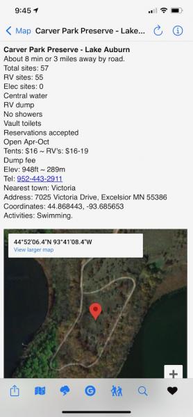
We use the Ultimate CG app first because it is a database of public campgrounds only and is our first choice. It covers all public campgrounds from National Parks to municipal parks. As a backup Allstays Camp & RV app is used for private campgrounds. We also make use of Harvest Host.
This is a view of the Ultimate CG app map. I chose the closest campground view where I live (the blue dot) for an example. It is in the 5,700 acre Carver Regional Park Preserve. We have had guest stay there since there is no place to park at our house. There is a 2-1/2 mile paved biking trail from our backyard over to the campground.
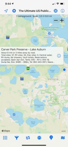
If you click on Info it brings up essential information including GPS coordinates.
__________________
Davydd
2021 Advanced RV 144 custom Sprinter
2015 Advanced RV Extended body Sprinter
2011 Great West Van Legend Sprinter
2005 Pleasure-way Plateau TS Sprinter
|
|
|
|
|
04-11-2021, 12:57 PM
|
#10
|
|
Platinum Member
Join Date: Oct 2014
Location: League City, TX
Posts: 1,168
|
Quote:
Originally Posted by VTPete
Having written cartographic mapping software (and database creation tools) all of my adult life, I agree it's difficult getting good source data!
Integrating data with a third party tool such as a TomTom or Garmin device comes with a host of problems. I would likely take the smartphone approach and distribute the candidate locations via either a live API or via a "download this area now because I think I'll be out of cell coverage later".
Your note (and other responses) are prompting me to look into data sources. Whipping up an app that does routing and mapping is simple with today's tools - but getting a good source of reliable information is tough!
-Pete
|
Subject for market research:
How many end users want to see plain vanilla public campgrounds (ugh, been done a dozen times) vs. how many want real-time preemptive signaling of available over-the-road resources?
I suspect that the research of others has yielded a much larger potential buyer pool in the former category, which is why the latter has been totally ignored.
But this is 2021, not 2005. The user pool is evolving. How hard could it be to write code that would inform me of every upcoming Subway, Chipotle, Walmart and Cracker Barrel along my charted route? All that data already exists - but I cannot selectively filter and call it.
I drive solo almost 3,000 miles from Houston Texas to northeastern Nova Scotia every year the operative word being solo. Because I have no co-pilot, I typically need to pull off the road to manually search for many resources on multiple cumbersome devices (cellular and GPS).
Husband and I started trying to crack the Garmins code for this reason. If I experience road fatigue at Mile 2,048 of that journey, then I would like to be able to glance at my Garmin and see icons displayed of every resource of interest **TO ME** (not of interest to Garmins paid advertisers) within 5 miles of that location.
Even better, I would like to tap the icon and be delivered waypoint navigation instructions directly to it.
Its not that hard to program, but husband and I didnt have time to do it - too many competing priorities. I would rather pay someone for that. Given the time and mental energy that it costs me to pull over continually, I would pay handsomely for something I could pre-select.
Now, I know what some people are going to say - you CAN give verbal commands to your Garmin. Yes I can. But the Garmins database is so poor that it misses 90% of what I want. And the verbal commands that are successful are only the most basic of them. Typical sequence:
GPS! (it wakes up)
Say a command, the Garmin replies.
FIND PLACE!
Speak the name of a place.
CRACKER BARREL!
Did you say Hacker Apparel?
NO!
Speak the name of a place.
(Bellowing at the top of my lungs) CRACKER BARREL
Did you say Crate and Barrel?
NO!
Ad nauseam.
And then even if it DOES produce the correct retailer, Garmin is programmed to send you to its advertisers preferentially. So its first act will be to re-vector you to a Cracker Barrel 12 miles in your rear view mirror.
^^ I cant even begin to stress how much room for improvement is in that. If I could just glance at the screen, see icons for my favorite retailers, and tap one...? Holy crap, that would be a dream come true.
|
|
|
|
|
04-11-2021, 03:40 PM
|
#11
|
|
Platinum Member
Join Date: Dec 2016
Location: America's Seaplane City, FL
Posts: 983
|
BTDT with Garmin
Quote:
Originally Posted by InterBlog
Subject for market research:
Snippage...
^^ I cant even begin to stress how much room for improvement is in that. If I could just glance at the screen, see icons for my favorite retailers, and tap one...? Holy crap, that would be a dream come true.
|
Google maps can do a lot of that pretty easily and shows deviation times. I.e. Gas stations, or Shell gas stations(while also showing some pricing), restaurants or Popeye's. (I have a weakness for their chicken sammich and Cajun fries).
__________________
Tick tock, baby(Ironbuttal)
2000 Roadtrek Chevy 200 Versatile(sold)
'98 Safari Trek 2480
Just for fun:'15 Kawasaki Versys650LT
Perfection is a fantasy, though improvement is possible(Wifey).
|
|
|
|
|
04-11-2021, 04:56 PM
|
#12
|
|
Site Team
Join Date: Jul 2013
Posts: 5,335
|
There are several services that do a tolerably good job at searching along your route. Last time I tried the AAA website (which was quite a while ago) it was pretty good. There are other good ones, but I can't remember off hand what they are. Also, built-in nav systems in higher-end cars often do this well. Our Volvo XC60 is quite good at it.
__________________
Now: 2022 Fully-custom buildout (Ford Transit EcoBoost AWD)
Formerly: 2005 Airstream Interstate (Sprinter 2500 T1N)
2014 Great West Vans Legend SE (Sprinter 3500 NCV3 I4)
|
|
|
|
|
04-11-2021, 05:26 PM
|
#13
|
|
Platinum Member
Join Date: Oct 2014
Location: League City, TX
Posts: 1,168
|
Quote:
Originally Posted by SteveJ
Google maps can do a lot of that pretty easily and shows deviation times. I.e. Gas stations, or Shell gas stations(while also showing some pricing), restaurants or Popeye's. (I have a weakness for their chicken sammich and Cajun fries).
|
Can you sketch for me how one would achieve a workable solution using Google Maps across 3,000 miles - and assume route diversions are also possible, as I have done in the past (e.g., divert to Philly to see Million Mile Sprinter).
Also keep in mind it would have to be aware of the freeway / tollway / parkway hazards throughout the northeast (most of us are too tall for parkways). Etc. Etc.
I cant yell instructions at Google. And TMK, nobody sells a sufficiently-crisp retrofit touch screen that can be read in full sun from behind the wheel. That is the one thing Garmin does really, really well - their screens are readable in all conditions, like magic. We have a very expensive Pioneer head unit - a pop-out 7 inch screen retrofit into the single-DIN radio slot. The screen quality is absolute trash, and we paid about $600 for the stupid thing.
Anything that causes me to have to pull over is just as bad as what I am working with right now.
|
|
|
|
|
04-12-2021, 04:08 AM
|
#14
|
|
Platinum Member
Join Date: Dec 2016
Location: America's Seaplane City, FL
Posts: 983
|
Quote:
Originally Posted by InterBlog
Can you sketch for me how one would achieve a workable solution using Google Maps across 3,000 miles - and assume route diversions are also possible, as I have done in the past (e.g., divert to Philly to see Million Mile Sprinter).
Also keep in mind it would have to be aware of the freeway / tollway / parkway hazards throughout the northeast (most of us are too tall for parkways). Etc. Etc.
I cant yell instructions at Google. And TMK, nobody sells a sufficiently-crisp retrofit touch screen that can be read in full sun from behind the wheel. That is the one thing Garmin does really, really well - their screens are readable in all conditions, like magic. We have a very expensive Pioneer head unit - a pop-out 7 inch screen retrofit into the single-DIN radio slot. The screen quality is absolute trash, and we paid about $600 for the stupid thing.
Anything that causes me to have to pull over is just as bad as what I am working with right now.
|
Across 3k miles, ufda! I don't plan that far in advance except for a general outline. But if I want to find a gas station or something else ahead I can ask the map to "find gas stations on my route" it will show gas stations, some with pricing. One can move the screen and get them farther out though I think you have to hit a refresh button. It also works on Android Auto running Google maps through our Kia Soul.
That second paragraph of expectations is pretty much not gonna get any help from Google, as far as I know.
Just trying to help.
Later.
__________________
Tick tock, baby(Ironbuttal)
2000 Roadtrek Chevy 200 Versatile(sold)
'98 Safari Trek 2480
Just for fun:'15 Kawasaki Versys650LT
Perfection is a fantasy, though improvement is possible(Wifey).
|
|
|
|
|
04-12-2021, 12:32 PM
|
#15
|
|
Platinum Member
Join Date: Feb 2015
Location: Oklahoma
Posts: 932
|
MrNomer has never driven the van without me as navigator. I have never driven it with a navigator. He does not comprehend how valuable a navigator is.
|
|
|
|
|
04-12-2021, 05:46 PM
|
#16
|
|
Platinum Member
Join Date: Dec 2016
Location: America's Seaplane City, FL
Posts: 983
|
Quote:
Originally Posted by MsNomer
MrNomer has never driven the van without me as navigator. I have never driven it with a navigator. He does not comprehend how valuable a navigator is.
|
I agree on your navigator viewpoint. MrsSteveJ, well let's just say that electronic gizmos are not her forte'.  Now quilting...
__________________
Tick tock, baby(Ironbuttal)
2000 Roadtrek Chevy 200 Versatile(sold)
'98 Safari Trek 2480
Just for fun:'15 Kawasaki Versys650LT
Perfection is a fantasy, though improvement is possible(Wifey).
|
|
|
|
|
04-15-2021, 04:01 PM
|
#17
|
|
Gold Member
Join Date: Feb 2020
Location: Florida
Posts: 86
|
Quote:
Originally Posted by VTPete
Having just returned from a 1,600 mile trip with my daughter, I realized that one of the largest problems I have is being spontaneous with our travels, but still being able to find a place to stay.
Being early April, it seemed as though nothing was open and we spent far too long searching the internet fruitlessly.
As an Apple application developer I couldn't help but to think that perhaps a tool already exists that combines routing with destination finding that is fine tuned for camping or boondocking.
How does everyone solve this problem of not wanting to have to plan ahead and still being able to find a place to spend the night? I mean if I was going to plan every step of my journey I might as well stay at hotels with reservations!
|
Hello, I find the same issue with RV parks. Seems like 2020 is the year of RV and camping so the parks are full. We have learned to watch the sites and hope. Then we have other plans. We can stay at some places for just one night (NOT Walmart anymore) such as Home Depot with permission, and also Harvest Host. Last resort is Pilots and Loves truck stops unless you can't sleep with noise.  LOL To many APP's and to much tracking going on with them in my opinion. We want off grid for a reason. I do recommend you watch some YouTubes and check with other RV travelers. Our Class B fits almost anywhere compared to the Class A and C's. Good luck and safe travels. Pray that schools reopen (no comment) and people go back to work more. LOL I have two long trips booked and had to adjust including a couple of cheap hotels along the way. Yes mix it up. 
|
|
|
|
|
04-15-2021, 04:05 PM
|
#18
|
|
Bronze Member
Join Date: Jan 2020
Location: Arizona
Posts: 44
|
Ultimate CG is a great source of information on public campgrounds and dispersed campsites, however it requires a network connection to function, something not always available in the boonies. We use the "Combined US Campgrounds by rivopom" POI file (available on the POI Factory) loaded into the CoPilot app on our Android tablet. The POI file has RV Parks as well as public campgrounds. CoPilot uses locally stored maps so does not need a network connection.
Jim
|
|
|
|
|
04-15-2021, 04:06 PM
|
#19
|
|
New Member
Join Date: May 2020
Location: Ontario Canada
Posts: 13
|
Boondockers Welcome - https://www.boondockerswelcome.com/ was my favourite overnight stay solution. After that it was KOA because I was travelling alone and unsure of unknown places. BUT there are many other places that are recommended by Boondockers and the hosts are more than generous in their willingness to help RVers.
|
|
|
|
|
04-15-2021, 04:20 PM
|
#20
|
|
Bronze Member
Join Date: May 2016
Location: Mt./NC
Posts: 46
|
Options
Look at Dyrt and rvtripwizard. Both good for route planning.
|
|
|
|
|
|
| Thread Tools |
|
|
| Display Modes |
 Linear Mode Linear Mode
|
 Posting Rules
|
You may not post new threads
You may not post replies
You may not post attachments
You may not edit your posts
HTML code is Off
|
|
|
|
 » Recent Threads
 |
|
|
|
|
|
|
|
|
|
|
|
|
|
|
|
|
|
|
|
|
|
|
|
|
|
|
|
|
|
|
|
|
|


